Most measures of “water risk” in the United States fail to account for infrastructure. Now, researchers have developed a model that they say more accurately calculates water risk based on local infrastructure.
From the paper, published in the March issue of Global Environmental Change:
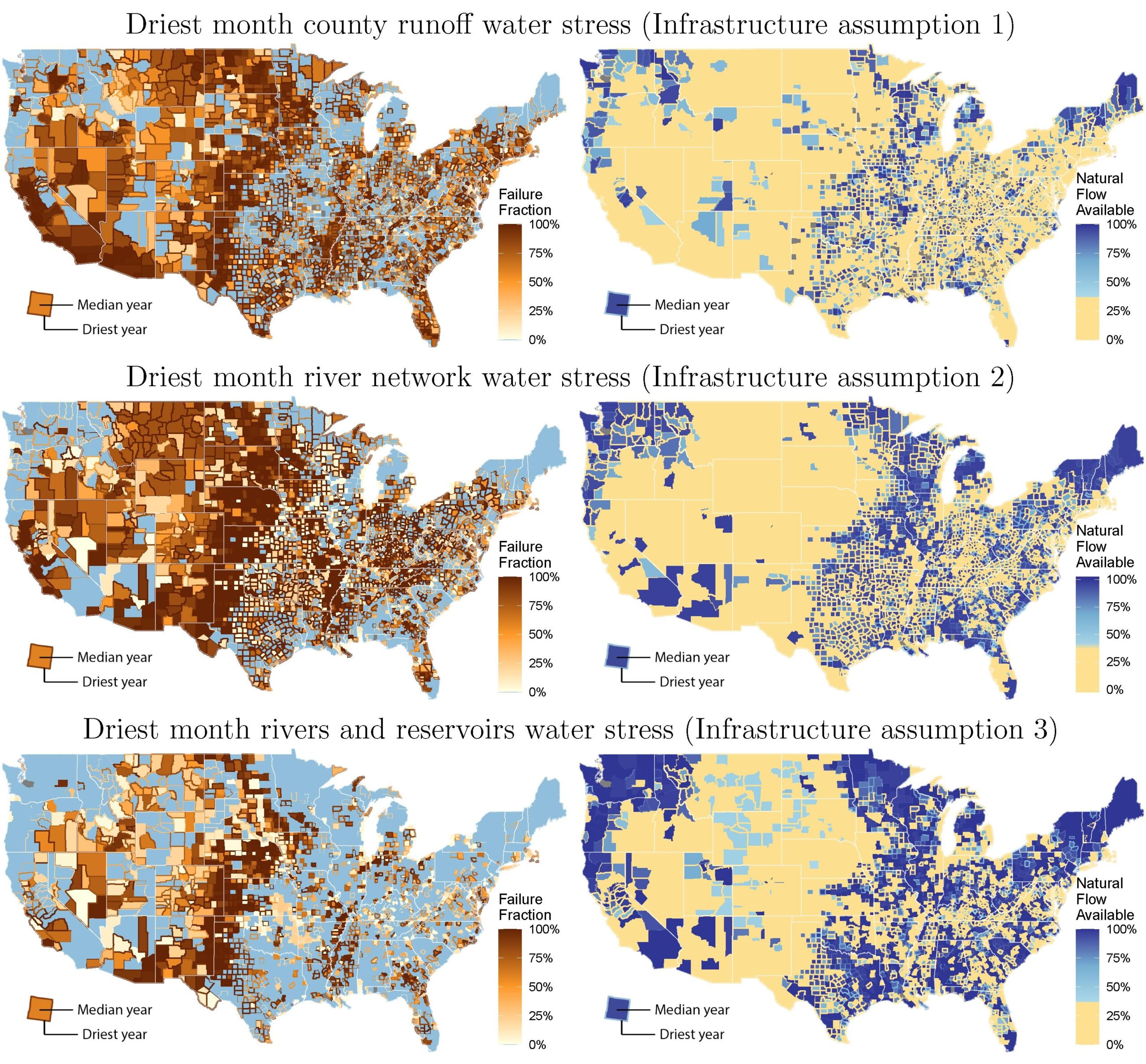
Most maps of “water risk” do not account for the role of infrastructure and rely on local runoff metrics, which may be a poor proxy for experienced water stress. We present a new spatial and multi-sectoral optimization model of resource networks, applied here to water resources in the United States. […] We find that considering the role of water conveyance and storage infrastructure in managing supply leads to a radically different picture of water risk, with substantial reductions due to both types of infrastructure – up to 60% reduction in risk due to conveyance and 38% due to storage. This highlights the importance of accounting of the role of infrastructure in national climate risk assessment and adaptation strategies.
Variations in the stress results show that water demand, infrastructure, and long-distance trade-offs are crucial for understanding the geography of climate risks. These underscore the importance of going beyond runoff-based, large-scale hydrological models to incorporate an explicit formulation of river connections and built infrastructure. Measures of water stress are significantly reduced by accounting for the long-distance flow, the transfer of water, and by including storage. River network connections reduce the estimate of total monthly water supply failures by 60%, and including reservoirs reduce potential failures by a further 38% (75% reductions in total failures compared to the county runoff case). In addition to these reductions, the stress is also redistributed spatially and temporally.
These substantial differences call into question the outcomes of studies centered on natural flows that bypasses the cumbersome modeling of water routing, allocation, and management. They challenge the relevance of the models and stress maps that routinely infuse policy briefs and inform water risk exposure for the financial sector (Josset and Concha Larrauri, 2021). It also implies that water scarcity projections associated to climate change scenarios require extensive modeling work that is currently non-existent.
Although we voice great concerns as to the possibility for the academic community to actually quantify scarcity given current gaps in information, our results show that water stress is a national issue in the US. Indeed, the model suggests that even with this infrastructure and under optimal allocation, much of the country remains susceptible to water stress in the driest months of the recent historical climate record.